Islay history
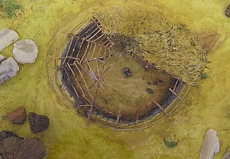
Chance finds of several distinctive Mesolithic flint tools and working debris, together with shell middens and occasional structural remains, indicate that Islay was occupied from at least as early as 10,000 BC. Many of these finds can be seen at the Museum of Islay Life in Port Charlotte. Occupation at this time may have been of a seasonal nature, taking advantage of the rich wild game and coastal food resources. Remains such as those found at Kilellan (Burgess, 1976) and Newton (MacCullagh, 1989) indicate that the buildings of this period were rough shelters dug into the sand.
As the climate improved, the fertile lands of Islay attracted the first farmers to come and settle. The remains of their houses and tombs are scattered throughout the island. Often, sites of this period first become visible through the exposure of middens, the accumulated refuse generated within settlements. A Late Neolithic-Early Bronze Age round house dating from around 2000 BC, excavated at Ardnave (Ritchie & Welfare, 1983) was found to contain food vessel type pottery and a wide range of stone tools. The Neolithic chambered cairn tombs found on Islay are part of a group known as the Clyde tombs and would have contained a long narrow passage with a chamber to one end. While seven such tombs are known on Islay, none lie within the coastal zone.
From the mid-second millennium BC onward, the archaeological record indicates social and cultural changes occurring. Not only is there a change in burial practice, from burial within communal tombs to individual burial in cists, but this is also the time when metal working technology and metal goods arrived on the Island. Several cist burials have been excavated at Ardnave (Ritchie & Welfare, 1983) and a probable funerary pyre was excavated by the authors during the course of the coastal survey (Moore & Wilson, forthcoming). A few chance finds of bronze artefacts are recorded from Islay, although little is known of the context from which they came.
Iron Age
The Iron Age on Islay, extending from the mid first millennium BC to the mid first millennium AD, is poorly researched. The only known broch site on the island is located at Dun Bhoraraic near Ballygrant. While there are numerous fortified dun sites throughout the island and especially on the coast edge, the period of their construction and use is little known, although it is probable that a proportion are of Iron Age date.
Further work will be required to determine if some of these sites were used as settlements or if they served exclusively for defensive purposes, such as look out positions. At this time, it is also likely that settlements on artificial islands within lochs, known as crannogs, were also in use. Even if all of the dun and crannog sites known to exist on Islay were in use during the Iron Age, which is unlikely, this leaves a large gap in our knowledge of how and where the bulk of the population lived at this time.
Early Historic period
From the Early Historic period, after c. 500 AD, onwards there is an increasing body of documentary sources with which to supplement the archaeological record. During this period, Christianity came to Islay, leaving its mark in a remarkable series of churches and carved stone crosses. Columba's missionaries established many early Christian sites, nowadays called chapels but back then started with the gaelic prefix "cill" which later transformed in "Kil" which can still be found in a lot of placenames. The missionaries built tiny churches which were continued during the period of the Norse colonists who later on adopted the Christion religion. Each district on Islay built its own church and burial ground.
Later commemorative crosses were set up in the burial grounds. Some of them can still be seen today at Kilnave and Kildalton, which is beautifully preserved and of great detail and also one of the few remaining in Scotland. Kildalton Cross is built in the Iona tradition with Pictish, Irish, Northumbrian and Celtic motifs. The cross is 2.7 metres tall and can be dated back as far as 800AD. At this time the political landscape was being redrawn, with the establishment of the Kingdom of Dal Riata in Argyll under the hegemony of powerful dynasties whose influence spread from Northern Ireland to Western Scotland. Documentary sources record that the chief group at this time on Islay were called the Cenel nOengusa who claimed descent from the high king of Northern Ireland.
By the latter part of the first millennium AD Scandinavian Vikings had arrived on the shores, first as raiders but later as traders and settlers. Communications and long-distance trading increased since Islay lay on the sea route between Viking colonies in Ireland and the Isle of Man and their homelands in Scandinavia. In time, the invaders married in to local families and settled down, being thereafter known as the Gael-Gall.
While Scandinavian place name elements may be found on Islay, few traces of their settlements have yet been found, although a few pagan Norse graves, such as at Ballinaby, have been found. From this society there came a number of powerful men, of which Somerled emerged pre-eminent. Of probable mixed Gaelic-Norse ancestry, Somerled came to prominence in the mid-12th century.
Taking advantage of opportunities provided by the death of King Olaf of Man, Somerled invaded the southern Hebridean isles in 1156 and established himself there as ruler. As a powerful warrior with a fleet of war ships to his name, Somerled continued to campaign in Ireland and against the King of Scotland. After his death, his son Ranald took his place, naming himself as King of the Isles and Lord of Argyll. In turn, his son Donald, founder of the Clan Donald, inherited the kingdom of Islay.
13th–14th centuries
Following defeat in battles against the Scots, the rule of the isles was ceded to the Scottish crown under the Treaty of Perth, signed in 1266. It was not until the MacDonalds under Angus Og, a descendant of Somerled, supported Robert Bruce in the Scottish Wars of Independence, that their fortunes were to rise again. On claiming his victory, the new King Robert granted back both forfeited and new lands to Angus Og in the early 14th century. Angus's son John is credited with being the first to give himself the title of Lord of the Isles.
15th–16th centuries
The power base of the lordship was centred at Finlaggan on Islay. Here, two islands in a freshwater loch surrounded by rich and fertile land, served as the lord's residence and court. For over one hundred and fifty years it was at Finlaggan that new lords were inaugurated and that the administrative Council, a quasi- parliament, met and deliberated.
The lordship was ended in 1493 when the last lord, John II was found to have acted treasonably in treating with the English king against King James III of Scotland and was defeated in battle by James IV. In the political vacuum which followed the fall of John II, there followed numerous rebellions and order was not restored until King James IV returned lands on Islay to John of Ardnamurchan, a MacDonald. Under his rule, a new court system was instigated, land valuations were carried out and the church was reformed. These changes were not universally accepted, however, and the threat of insurrection remained ever present.
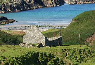
It is likely that the castle at Dunyvaig near Lagavullin, already a well used stronghold which may once have been used by Somerled, was refortified during this period. On the death of John of Ardnamurchan, administration of the Islay estates was passed firstly to Sir John Campbell of Cawdor and latterly in 1528, to The Earl of Argyll, Alexander MacIan. Finally, after disagreement, much of the lands fell to King James V in 1542. A rebellion led by Donald Dubh to regain power was put down and, with it, the hopes of restoring the lordship for ever.
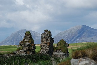
Feuding continued on a smaller scale, however, culminating with a battle at Loch Gruinart between the MacDonalds and MacLeans over the ownership of the Rhinns. The battlefield site can still be located and burials said to represent the slain from this battle have been reported nearby.
17th century
The downfall of the MacDonalds provided opportunities for the rise of the Campbells, who acted both as representatives of the crown and as chiefly rulers. They continued to expand their influence and land holdings, including those on Islay, until by the 17th century they occupied a dominant position and Islay gradually came under Mainland Scottish influence. The Campbells acted largely as absentee lairds and despite some attempts to improve farming and introduce new industry, Islay languished for much of the 17th century.
18th century
By the early 18th century, following years of hardship and famine which brought poor returns to its owners, the Cawdor Campbells were forced to sell their estates on Islay to Daniel Campbell of Shawfield, a wealthy tobacco baron and member of Parliament. With the change of ownership, the fortunes of the island began to revive.
In addition to introducing improved farming methods, the new proprietor also introduced flax cultivation and mills and weavers to engage in linen production. His successor, Daniel the Younger, was responsible for further improvements, including the laying out and construction of the village of Bowmore, the development of the fishing industry, the provision of schools and the promotion of the church.
From 1777, under the lairdship of his brother, Walter Campbell, the pace of change was to increase, as new roads and transport links were made, opening new markets. Further agrarian reform took place and the fishing industry was further promoted with the construction of new quays.
19th century
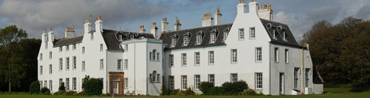
By the time that Walter Frederick Campbell took over from his grandfather in 1816 the population of Islay had expanded greatly and while many people chose to emigrate to the New World, those remaining at home required the means of earning a living. To meet these needs, Walter Frederick Campbell embarked on a programme of development which was to see the setting up of the villages of Port Ellen, Port Charlotte and Port Wemyss, widespread land improvement in favour of individual small holdings and land reclamation, and the more commercial development of the distilling industry.
While this set in place many of the factors which today contribute greatly to the economy and infrastructure of the island, it did not stem emigration from the island and by the 1840's, when the potato famine began to hit Islay, emigration to the New World and New Zealand, in particular, was promoted by the laird. In addition to inherited debts, the hardship of the potato famine and low returns from the land led Walter Frederick Campbell to bankruptcy in 1848; his lands were sequestrated and held in trust on behalf of his creditors.
A less benign rule followed, overseen by accountants and administrators, during which land clearances were carried out. The estates of Islay were eventually sold off in 1853. Over time, the estates were split up and sold off to private individuals, many of whom promoted emigration and most of whom had little long term concern with the development of the island or the condition of its inhabitants.
20th century
By the 20th century many of the private lands were owned by absentee landlords and either rented as tenant farms or developed as shooting estates. Much of Islay remains in the ownership of a few individuals to this day. The successful distillery industry, with ten functioning distilleries and a maltings, and increasing revenue from tourism has, however, provided new sources of income in addition to farming. The improvement of the road network and the instigation of a daily ferry and regular air service has opened the island up to new markets and new influences.
Further reading:
Local History Project from 1968 by Isle of Islay Federation, Scottish Women's Rural Institute
Extract from the Islay report by the scape trust