Loch Gorm
Loch Gorm is less than a mile from the Atlantic coast, roughly between Machir Bay in the south and Saligo Bay in the west. From Bridgend, the easiest road to get there is the B8018 a mile before Bruichladdich on the right, signposted Sanaigmore. After half a mile on this road you reach a hill just after Foreland House.
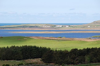
There are stunning views towards Loch Gruinart and Loch Indaal; you can even see the mountains on the Isle of Mull when the weather is clear. Just before Machir and Kilchoman the road goes right towards Ballinaby and ends finally at the same B8018 close to Carnduncan. This is a very nice, quiet circular road around the loch with plenty of opportunities for wildlife.
The loch
The area around Loch Gorm is mostly flat and differs from other parts of Islay. Loch Gorm is the island’s largest freshwater loch and is great for fishing – its brown trout are among the best on Islay.
Drive or walk the circular road at dawn or dusk and you’ll discover a wildlife fest: it’s amazing how much there is to see from the roadside. There are frequent sightings of buzzards, hen harriers, curlews, geese, roe deer, lapwing, pheasant, hares and many others.
In the south-east corner of Loch Gorm, on a small island, are the overgrown ruins of Loch Gorm castle, a former fort of the MacDonalds clan destroyed in the 1700s.
If you’re driving around on the little single-track roads in the evening, you’ll easily spot hares and deer. Views from the elevated parts of the road east from the loch, towards the Atlantic Ocean are magnificent, especially at sunset. With Kilchoman and Machir Bay to the south, and Saligo Bay to the west, Loch Gorm is extremely interesting.
Kilchoman
The most westerly whisky distillery in Scotland, Kilchoman Distillery opened at Rockside farm in 2004-5. In the graveyard next to Kilchoman church you can find the Kilchoman cross. The church itself is a ruin, but the Kilchoman cross is in a very good condition, making it worth a visit.
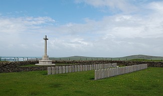
It’s a short walk south of the churchyard to the World War I graves where victims from HMS Otranto are buried. Halfway along this walk, when you cross the field, you can find the last remaining sanctuary stone. This stone, together with another in the Islay Museum, and the church itself, once provided a sanctuary.
Machir and Saligo Bay
Drive back towards Machir and a track to the left takes you to Machir Bay, one of the finest beaches and bays on Islay. If you like your sunsets, Machir Bay and Saligo Bay are where you want to be.
Machir Bay offers almost one and a half miles of sandy beach on the Atlantic coast. After a storm the waves can be huge and the walk to the end of the beach is very rewarding. At the south end of the beach a track leads uphill towards Kilchiaran; here between the rocky outcrops you can find the Iron Age fort of Dun Chroisprig as well as Granny’s Rock, which looks just like an old woman.